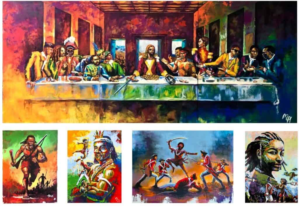
Yarumein through Indigenous Resistance and Genocide: Connecting Reparatory and Climate Justice
Nyala Thompson Grunwald, Researcher with The Repair Campaign
24th October 2025
The specific history of European colonisation in Yarumein i is driven by the genocide and repression of its indigenous peoples; those that were First People indigenous to the island and region, and those that became indigenous through the Middle Passage, but not through chattel enslavement in St Vincent – the Garifuna people.ii Through the centuries of European colonisation and brutality in St Vincent specifically, indigenous peoples – First People and made-indigenous – consistently and fiercely resisted European attempts and gradual invasion, whatever flag they carried.
Post the encounter of Kalinago, Taino peoples with European invaders – whose charge was first led by one of many mass murderers to come to the Caribbean, Christopher Columbus – the histories of First People indigenous civilisations is to a great extent marked by genocide and by the tense negotiations with several European colonial powers as strategies of survival.
These strategies were exercised by indigenous communities who, under conditions of extreme persecution and repression, were forced to survive in the margins iii of European colonisation in the Caribbean. Survival, both politically as existing between enslavers and the master settler/planter class, as well as spatially, often pushed into environments deemed ‘hostile’ within a given island. The economies and systems of colonialism were brutally implemented through the disposability of African bodies alongside the disposability of land and environment – this blog post briefly looks at these connections in St Vincent and the Grenadines.
Resistance
In Yarumein, Kalinago First People indigenous and Garifuna indigenous peoples fiercely resisted European attempts at invading and settling, only beginning to tolerate French settlement on the south and South-Western coast, a tense alliance existing to a great extent to keep British colonisation at bay. When the British invaded and then signed off on colonising St Vincent and the Grenadines (including signing a treaty with the Garifuna and Kalinago leaders which would split the island between the British colonial settlement and indigenous communities), consistent resistance became all out war that the Garifuna and Kalinago peoples waged with the British, first in 1769-73, then in 1795-96. Between these two wars, the French re-invaded St Vincent and the Grenadines, in 1779, before the British re-invaded and signed off on their uninterrupted colonisation of these islands in 1783 – this again, included treaties signed with Garifuna and Kalinago leaders.iv In St Vincent, every treaty that the British colonisers signed with indigenous peoples they breached – historically, colonial powers were never interested in any form of long-term cohabitation that impeded on their profits and theft of resources. British imperialism was no exception.
The so-called ‘Carib Wars’ in 1769-73 and 1795-96 were both marked by the specific forms of strategic warfare utilised by Kalinago and Garifuna peoples, notably led by Paramount Chief Joseph Chatoyer. Likewise, such as several conflicts between indigenous communities in the Caribbean with European invaders, the former utilised generational knowledge of island and environment as an advantage to trap, block, maneouvre around those forces hostile to their island. After the ambush and murder of Chatoyer in 1796, the Garifuna and Kalinago resistance was gradually overwhelmed by the British invading forces. In July of 1797, the British deported – of 9000 Garifuna and Kalinago people remaining in Yarumein – 4,776 persons from these indigenous peoples. The British deported 4,633 Garifuna persons, 102 Kalinago persons, 41 Africans to the island of Balliceaux in the Grenadines.v 4,776 persons were held in Balliceaux crowded in an open-air concentration camp with no way to subsist but what the rocky island (to be clear, Balliceaux is miniscule) would yield. By December of 1797, 50.5% of the deported population had been killed by this gradual and deliberate forced starvation. In December of 1797, the remaining Garifuna people on the island of Balliceaux were deported across the Caribbean Sea to the island of Roatan off of the coast of then British Honduras – before and after colonisation, Belize – to be dispersed across the rest of the American continent.
The history of the Garifuna people of Yarumein is fairly unique within a region defined by the forced transplantation of peoples and communities in respective islands: whereas we as Caribbean people are twice diasporised, being made-indigenous to the Caribbean (and whichever island within the archipelago self) and being diasporic to the Caribbean when departed from it, the Garifuna people were borne of the Caribbean during its colonial history.
Garifuna people pre-date made-indigeneity of the rest of the Caribbean today, yet are not First People-indigenous of a pre-Columbus era, they are First People-indigenous to the Caribbean self from its pivotal shift under the genocidal invasion and dynamic of European colonisation.
Chattel Enslavement
From 1764-1808, 62,176 African captives were trafficked across the Middle Passage to St Vincent and the Grenadines, distributed across plantations in the Grenadine islands – Mustique, Bequia, Canouan, Tobago Cays, Mayreau, Union Island – and in St Vincent. Significantly, chattel enslavement was developed in St Vincent alongside tense treaties – as mentioned above – that British colonisers signed with the Garifuna and Kalinago peoples. Several sources put together a story of British colonisation as dependent on the dispossession of indigenous lands and relying on the erasure of Kalinago and Garifuna indigenous communities to expand their extractive plantation industry on the main island of St Vincent.<sup>vi</sup>
The treaties between indigenous communities and the British outlined where the Garifuna and Kalinago peoples withheld unconditional land sovereignty and ownership in areas in the main island. This is indicated clearly by lines in the Byres 1794 map [pictured above], which outlines, based on the 1763 treaty, that areas from north of Wallibou river across la Soufrière volcano to the central east stretching down to the Byera River were where

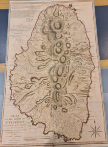
stretched the ‘Charib’ boundary. South of each boundary stretched the parishes where the British had fully implemented plantation estates. On the map, these parishes have the names of St David’s, St Andrews, St Georges’, St Patrick’s. Between each so-termed ‘Charib’ boundary (so, at the Wallibou River on the west of the island and at the Byera River on the east of the island) and the British occupied parishes are indicated areas with ‘cultivable lands remaining undisposed of’. I’ll come back to those in a bit.
After the mass deportation of just under half of the remaining indigenous communities in Yarumein in 1797, the land previously demarcated on the 1794 map (before the second war with the Garifuna and Kalinago peoples), was carved up into plantation estates for the monocultural and unsustainable cultivation of sugarcane, coffee, cocoa. There were still just over 4,000 Kalinago populations remaining in Yarumein after the 1797 deportation. British colonisation encroached on a further 95 acresvii of stolen indigenous lands to expand their plantation economy in St Vincent, which can be partly understood through a few notes:
- A contemporary map of St Vincent places the St David’s parish as now stretching further north of the Wallibou River, bordering with the Charlotte parish. The Charlotte parish stretches down from the North-East down past the Byera River bordering with St George’s parish. The Centre for the Study of the Legacy of British Slavery (CSLBS) database for plantation estates indicates distinct parishes within St Vincent and the Grenadines, including Charlotte on the main island – as seen above, the Charlotte parish did not exist as chartered on the 1794 map.viii
- An 1888 map of St Vincent and the Grenadines marks an area indicated as ‘Carib territory’, a fraction of the land allocated according to the 1794 map, just north-east of the La Soufrière volcano. Note that indigenous land ownership on St Vincent was outlawed in 1804ix, which means that the land parcelled out for indigenous communities as indicated in 1888 was under some form of ‘loan’, possibly fiscal, possibly literally – indigenous communities forced to reside only on a certain area of colonial property ‘loaned’ out to them.
It would appear that the 95 acres stolen by the British after 1796 were carved up into plantation estates that made up the bulk of another parish, Charlotte, as well as extending St David’s parish. For a fuller picture, this could be put together with the [according to the 1794 map] noted ‘cultivable lands that remain undisposed of’, which were respectively in the St David’s and, at the time, in between St George’s parish and the ‘Charib’ boundary (therefore under colonial occupation):
- The areas marked as ‘cultivable lands un disposed of’ in the 1794 map appear to have been re-distributed within the parameters of the St David’s and Charlotte parishes.
- According to the records of the CSLBS, it is possible to find which estates have recorded claims from the late 1790s (so after the further encroachment on Kalinago lands) in the estates of Charlotte and St David’s, such as the Camacarabou, Colonarie Farm, Hyndford, Mesopotamia estates in Charlotte.x
- Of these, only Camacarabou holds a record as far back as 1792, the rest from 1799 onwards – Colonarie Farm for instance, holds records from 1817 alone.
- It would require far more depth and time to place where exactly these estates lay. – Colonarie Farm is an exception, where records indicate an area today called Colonarie, south of Byera Hill and stretching on either side of what, in the 1794 map, was the Byera River bordering ‘Charib’ territory with the British capture lands.
- Only the Camacarabou estate has a record pre-dating the Second ‘Carib’ War in St Vincent, therefore pre-dating the re-chartering of lands previously attributed to Garifuna and Kalinago peoples, and pre-dating the Charlotte parish.
- Without knowing where the Camacarabou plantation estate actually lay, the question remains whether this estate was part of these as yet ‘undisposed of’ lands – therefore within the area that would later become a part of the Charlotte parish, but was still under British occupation before the Second ‘Carib’ War.
This snapshotxi theorisation of histories of the geographies of the Vincentian plantation economy parallel to the consistent resistance of Garifuna and Kalinago peoples throughout the 18th century is a crucial part of the story of colonisation in St Vincent and the Grenadines.
The Garifuna and Kalinago peoples clearly stood as an obstacle to British extractive colonisation, and their deportation and gradual erasure were crucial to the British quest of complete domination and colonisation of the main island. This is later reflected in the profits the British Empire reaped from the genocidal conditions of chattel enslavement as implemented in St Vincent:
“For the greater part of the period 1807-1834, St Vincent was the leading sugar producer in the Windward Islands…The Windward parishes became increasingly monocultural, and by the 1830s coffee and cocoa production was largely confined to the leeward parishes of St Patrick and St David”
- By 1810 – so in 46 years of the implementation of chattel enslavement and plantation estates under the British – near 70% of the enslaved population were distributed to sugar estates across St Vincent and the Grenadines. By 1830 this number had grown to 80%.xiii
- Likewise in 1810, an estimate of 10,447.5 tons of sugar were produced per enslaved population of 20,895 persons on sugar plantation estates – this is 0.50 tons per enslaved person alone. This, in 1830, is an estimate of 10,528 tons produced per enslaved population of 22,400 persons distributed to sugar plantations.xiv The quantity of sugar produced per the portion of enslaved population in St Vincent that were coerced onto sugar estates, by mere number alone, illustrates the scale of profit that was exported directly to the British metropole, as well as the brutal, extractive and over-exhaustive conditions of chattel enslavement.
- Sugar cultivation required large plantation space, as well as ruthless technology, and yielded crops on quickly degrading soil. The technology and equipment used was brutal and often lethal: profits reaped in sugar were harvested through the blood and destruction of human and environmental bodies.
Climate Justice
The above is only a few perspectives from centuries of genocide wreaked on the First People indigenous and Garifuna indigenous peoples in Yarumein, of the ecological devastation triggered by the implementation of plantation estates in St Vincent. Put together in this brief post, it is only a lens into the vast wealth reaped through the mass enslavement of Africans trafficked to St Vincent, enabled on such a wide scale through the near-total erasure of indigenous communities, deportation of the Garifuna people, and subsequent land theft for the production of space according to the unsustainable principles of colonial inhabitation.
St Vincent and the Grenadines holds a unique history and unique records of the “dual harms of Indigenous genocide and plantation slavery”.
The layered devastation of colonialism shaped not only the deliberate underdevelopment of St Vincent and the Grenadines in every part of the makeup of its society and economy, but also the levelling of natural ecosystems into extractive models.
These are relational, not isolated developments within historical and present realities. There is, as illustrated for instance in the trajectory of St Vincent and the Grenadines, clear “unjust enrichment” of colonial beneficiaries that has been destructively detrimental to the overall growth, self-sufficiency and development of St Vincent and the Grenadines. Historically Yarumein and then Vincentian populations – those First People, indigenous and made-indigenous – have consistently resisted and created alternative economies from the wreckage of the plantation estates. Certainly in the 19th century, arrowroot already accounted for 50% of St Vincent’s minor exports in 1834, the crop being grown primarily on provision grounds.[i]
The geography of St Vincent, put through the brutal extraction of colonisation, has left traces in the land which translate to very real climate vulnerability that has only increased in the accelerating climate breakdown of recent years. This is shaped in a unique way in St Vincent and the Grenadines alongside the islands-specific trauma of chattel enslavement and subsequent dispossession of made-indigenous Vincentian populations. We all remember Hurricane Beryl, and that was a category 5 hurricane right at the beginning of the 2024 season. Reparations are a clear necessity to account for the harm perpetuated through colonial infrastructure and inherited in a bloody legacy inscribed in land and people.
iThere are 2 supposedly ‘indigenous’ names for St Vincent and the Grenadines: Yarumein, and Hairouna/Hirouna. Hairouna means ‘land of the blessed’. According to insight from Akley Olton – visual artist and filmmaker in St Vincent – and sources otherwise, Hairouna was part of a political project coming from the 1930s Labour riots but has no historical grounding whatsoever in indigenous histories.
Footnote for the end of the paragraph: Maroon communities in Caribbean islands, in Brazil, in the Guianas (at the time torn between three colonial jurisdictions) are also included in this particular form of marginal existence.
ii As a note on vocabulary, during this post I will use both ‘First People indigenous’ and ‘indigenous’ or ‘made indigenous’. I mark the difference as stated in the above sentence: those who were ‘First People’, that is the Ciboney, Kalinago, Taino…peoples and civilisations that inhabited, held strong economic trading networks, waged war, moved between the archipelago and what is now the northern part of ‘Latin’ America. And those ‘indigenous’ or ‘made indigenous’ who were forced to become ‘new natives in a new world’. I will use ‘indigenous communities’ or ‘indigenous peoples’ where necessary to indicate the plural of these two forms of indigeneity. There are several ways to say that (including the above), this way is chosen as it accounts for the distinctions of indigeneity as specifically formulated in the Caribbean, as well as attempting to encompass the vast First People indigenous peoples plural that we hold minimal to little records of today.
iii Please note the use of ‘margins of European colonisation’ as distinct from existing within the margins of life and death, of human and sub-human, of commodity and commodified – this is specific to the survival of captive trafficked and then enslaved Africans in the Caribbean plantation system.
iv As a note, the years 1763 and 1783 are significant in the history of European colonisation in the Caribbean from 1492: the Treaty of Paris in 1763 and Treaty of Versailles in 1783 brought to the forefront the globality of European inter-regional warfare as it affected colonised areas. For instance, several islands in the Caribbean will mark points of handover between colonial powers at these same dates, under those treaties.
v The Repair Campaign research
vi Primarily in use here are: Byres (1794), ‘Plan of the Island of Saint Vincent laid down by actual survey under the direction of the Commissioners for the Sale of Lands in the ceded Islands’, held and accessed at the British Library Archives 25/03/25 by NTG , Centre for the Legacies of British Slavery, directed by Professor Matthew Smith at the University College London (UCL), Lucas (1888), A Historical Geography of the British Colonies, Clarendon Press Oxford, vol.2 p.227, held at the British Library archives, accessed through WCommons by NTG
viiThe Repair Campaign research
viii Each Grenadine island was listed in CSLBS records as one parish (with French and Creole names, which could illustrate a very distinct colonial dynamic in the Grenadines self, as well as with the more inscribed British Vincentian land, and what that could reveal about relationships today within communities living in the main island of St Vincent and those in the Grenadines)
ixThe Repair Campaign research
x please note that information pertaining to the Charlotte parish is slightly flawed, as even with the 1888 map used, as far as collected records indicate, we cannot quite tell where the parish itself was first chartered immediately following 1796. I chose to focus on the estates in Charlotte as that was an entirely new parish carved up following the last of the so-called ‘Carib’ Wars in 1796. It is therefore clearer when those states were sold and how smaller carved up estates were collapsed into larger sugar plantation units than for estates in St David’s, which existed prior to the end of the Second ‘Carib’ War.
xi This analysis is pulled from research of latest available information. It is not representative of the entirety of the research that went into this, neither is it representative as a singular and definite story of the experience of Vincentian history of chattel enslavement and legacies today: this post is a part of these stories
xii Higman (1986), Slave Populations in the British Caribbean, 1807-1843, ?? Press, p.55
xiii See previous reference
xiv 22,400 persons is not the total enslaved population in St Vincent and the Grenadines, it is the total number of that population that are coerced into labouring sugar plantations alone. Primary data from Higman, analysis from TRC research